What happens to industrial sites in de-industrialized cities?
Often, there are even more issues than just environmental racism at play. Read More
Adapted from Sites Unseen: Uncovering Hidden Hazards in American Cities (Published by Russell Sage Foundation 2018)
Situated just north of Philadelphia’s central business district along the banks of the Delaware River, an old manufacturing area called Northern Liberties is booming — again. But this time, it is not the factory whistles blowing from the nearby J.E. Lonergan Company (steam valves and other locomotive parts and lubricants), the American Can Company (yes, tin cans) or the Rohm & Haas Company (synthetic chemicals and dyes) that draw workers and their families to the area.
Today instead bistros and gastropubs, art galleries and boutique shops linked by a newly developed walking mall and public plaza attract a very different — significantly wealthier and comparably whiter — group of residents to “Nolibs.”

A two-acre community-developed garden space and children’s playground dubbed “Liberty Lands” sits atop a reclaimed Superfund site once occupied by the Burk Brothers Tannery. Described by local boosters as “a hotbed of enviro-friendly construction” designed to complement “ambitious mixed-use complexes that reimagined overlooked industrial bones,” the rapidly gentrifying neighborhood is trading heavily and, it seems successfully, on its industrial past.
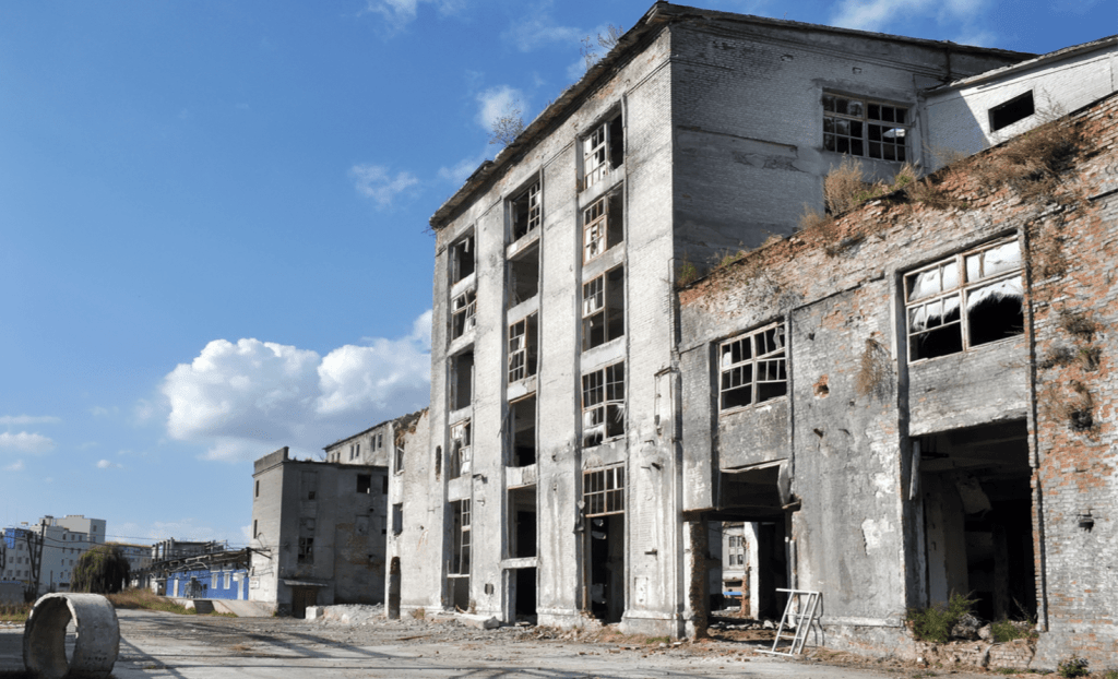
Present-day industry, by contrast, is virtually nonexistent in Northern Liberties and the adjoining riverfront area just to its south. Only six manufacturing facilities were operating there in 2008 when our study period ends. The oldest of these, an industrial parts manufacturer founded by German immigrants in the 1850s, employs around 25 workers, but the other five are much smaller metal fabrication operations.
In 1956, when our study period begins, the neighborhood’s streets would have looked, smelled and sounded much different. For one thing, at that time 97 manufacturing facilities were operating here, crowded onto a 1.5-square-mile patch of densely settled urban land. Fully two-thirds of these facilities were metal fabrication and industrial machinery shops much like the handful of facilities operating today.
But the industrial profile of the area was also much broader back then. The Loos & Dilworth Co., a firm that produced commercial and industrial petroleum-based lubricants, operated there, as did 22 chemical plants, including Rorer, Inc. (pharmaceutical chemicals), which employed 166, and Wetherill & Co. (paints, varnishes and oils), which employed 85. The area was crowded with several other larger facilities, such as the tannery, which has become today’s garden and hangout spot for children and dog walkers.
We care about sites of relic industrial waste like these not solely because of the environmental risks they may pose. We also care because the wastes they harbor have gone missing, buried in parcels of land once occupied by older factories that no longer operate. In their place, we are instead likely to find restaurants, coffee shops, playgrounds, retail clothing stores, artist studios, and other seemingly benign land uses — anything and everything urban land gets used for today.
This reuse occurs because the historical processes that once generated older, now-relic sites of industrial waste are ongoing. In time, even today’s newer factories will go out of business and their industrialized lots will be sold or rented and put to other uses. And because a large percentage of these newer factories are small, they too will have escaped current federal reporting requirements.
Between the 1950s and 2017, deindustrialization hit the Northern Liberties area and adjacent neighborhoods hard, but it did not keep new hazardous manufacturers from opening and closing. Our data indicate 224 relic sites by 2008 — 37 times the number of currently operating sites and more than twice the number operating in the mid-1950s.
Nearly all of these relic sites (88 percent) were occupied by facilities that opened and closed before the mid-1980s, when the Environmental Protection Agency’s (EPA’s) Toxics Release Inventory (TRI) reporting requirements began. For decades, many of these shuttered factories and shops sat empty or were leveled by city planners, leaving the neighborhood a shadow of its former self. Yet a core of the area (a small, one-tenth of a square mile section running from 3rd to 6th streets and from Vine to Green streets) holds the distinction of having the most heavily concentrated relic site accumulation of any of the 492 historicized census tracts in our study. Our calculations indicate more than 500 former sites of hazardous manufacturing per square mile, which, if distributed evenly over space, would yield a relic site every 90 yards.
Of course, this is an extreme case and includes only one part of one neighborhood in one city. But what if the dynamics that generated a virtual mountain of relic industrial sites in and around Northern Liberties were at work — even at much lower rates — in other neighborhoods in this and other cities?
Importantly, many relic sites tend not to be in predominantly low-income or minority neighborhoods, and the proportion of those that are has been declining over the past few decades, as new generations of white residents churn back into the nation’s urban cores. These developments hold true even in predominantly black cities such as New Orleans and Philadelphia.
On its face, this narrative may seem to run counter to the more conventional story that environmental burdens are always and unequally borne by residents of poorer, nonwhite neighborhoods and that over the past few decades this situation has become worse, not better. In fact, the two stories are more compatible, one nested within the other.
Our story highlights how environmental inequality is declining because the spatial and temporal accumulation of industrialized land is steadily increasing at the same time that residential churning is again shifting who lives where. These dynamics do not mean that minorities and low-income groups are less at risk than earlier studies have indicated; instead, our findings show that whites and middle-income groups also face more risk than scholars previously have realized.
Both stories are accurate and meaningful — and inextricably related. The unjust exposure of marginalized groups to industrial hazards, especially large, active ones in particular neighborhoods, is a big part of the contemporaneous process, the now. The environmental consequences of this unjust exposure playing out over and over again in conjunction with residential churning and risk containment are the cumulative process, the later.
Environmental injustices of today beget and hide systemic risks of tomorrow, as past and present continue to unfold atop one another, again and again. This is what we mean by succession: change upon change that does not move cities uniformly in one direction or another so much as accumulate, deepen and spread in ways that are historically contingent and tied to local particularities of ecology, culture and politics. Our story and the more conventional one use different kinds of information and are set within different frameworks — one emphasizing current industrial activities and exposures, the other transitions from active to relic industrial sites and the potential risks posed by legacy hazards. Only by understanding these differences can we square the seemingly divergent — but ultimately entwined — stories we tell about environmental inequality and systemic risk in American cities.